 As the Canadian Press put it in their article today, "Arctic Ship Searchers Come Up Cold this year." It's not the news we had all hoped to hear, but it's not entirely discouraging either. I have always felt that a large part of the difficulty in finding traces of Franklin's ships is that the area is, simply put, too vast to be searched without a significant, concerted effort over a period of time. Compared to the total area in which the ships may possibly be found, only a tiny percentage has ever before been systematically searched; by adding (by all accounts) a significant area to that total, this years's expedition increased the likelihood of success next year. According to the article, the team searched "150 square kilometres of sea floor under the waters near O'Reilly Island on the east side of Queen Maud Gulf." Some of this area, of course, had already been covered by Dave Woodman's earlier magnetometer searches, although that search may possibly have missed non-metallic targets, so in any case the news represents a meaningful step forward. I hold out great hope for next year's survey, and that the Canadian government and Parks Canada will redouble their efforts - and that they may find at least some trace of one of those long-lost vessels.
Monday, August 30, 2010
No Franklin ships this year
As the Canadian Press put it in their article today, "Arctic Ship Searchers Come Up Cold this year." It's not the news we had all hoped to hear, but it's not entirely discouraging either. I have always felt that a large part of the difficulty in finding traces of Franklin's ships is that the area is, simply put, too vast to be searched without a significant, concerted effort over a period of time. Compared to the total area in which the ships may possibly be found, only a tiny percentage has ever before been systematically searched; by adding (by all accounts) a significant area to that total, this years's expedition increased the likelihood of success next year. According to the article, the team searched "150 square kilometres of sea floor under the waters near O'Reilly Island on the east side of Queen Maud Gulf." Some of this area, of course, had already been covered by Dave Woodman's earlier magnetometer searches, although that search may possibly have missed non-metallic targets, so in any case the news represents a meaningful step forward. I hold out great hope for next year's survey, and that the Canadian government and Parks Canada will redouble their efforts - and that they may find at least some trace of one of those long-lost vessels.
Friday, August 27, 2010
New Franklin Drama
 The history of Sir John Franklin on stage and screen is a lengthy one, and goes all the way back to Wilkie Collins and Charles Dickens's stage-play, The Frozen Deep, in 1857. I now hear that there's to be a new, more experimentally-minded Franklin drama put on in Chicago at The Building Stage. Entitled "The Franklin Expidition" (not sure whether this is a typographical error or a sign of the pernicious influence of Inglourious Basterds) it's billed as a "completely unique original production," one which "rather than telling the story of any single expedition ... uses the character of Franklin to get at the heart of exploring, embracing the risk of vulnerability and the unknown, and the universal challenge of connecting our everyday actions with our deepest desires." Well, I'm not sure what exactly this means, but I'm certain it will be worth seeing if you live in or near the Chicago area. I'll keep everyone updated as more details on the production emerge; tickets go on sale September 1st.
Wednesday, August 25, 2010
The Track of CCGS Laurier
 [UPDATED AUG 29] As noted in a response to an earlier post, the CCGS Laurier's online track shows a route rather different than expected (thanks again to Dave Woodman for alerting me to this possibility). Using sailwx.info, one can get almost hourly updates on the vessel's current location, which shows that, rather than remaining in Queen Maud gulf, it ascended the eastern coast of King William Island as far as Matty Island. Some have inferred from this that the searchers are following up on latter-day Inuit accounts, collected by Dorothy Eber, of one of Franklin's ships being in this area, but although that's possible, I'm not sure how much we can infer from this ship's tracking data. For one, the searchers have the use of two launches, the Gannet and the Kinglett, which could enable them to conduct surveys independently of the Laurier. For two, the Laurier, a multi-purpose vessel with many tasks, may well be moving in response to other needs and obligations -- servicing navigational beacons, search and rescue, and so forth.
The August 19th update from Parks Canada is consistent with this; it indicates that
With the two Canadian Hydrographic survey launches, Gannet and Kinglett readied prior to arrival, the marine search began immediately with a side-scan sonar deployed from each launch. The side-scan sonar is towed from the stern of the launch vessel, offering an acoustic image of the sea floor. During surveys with the side-scan sonar, our team will systematically cover as much of the targeted area as possible.
It's a little frustrating that the update doesn't mention the exact location of the "targeted area," but it's clear that it's in Queen Maud Gulf, as they mention consulting ice charts of that area. I'm relieved to learn that this is indeed the area of their work, and that they're focusing on covering as wide of an area as possible in the available time; I'm certain that's the right approach. After all, readers will recall that, in the search for RMS Titanic, Bob Ballard's team and a rival French outfit were trolling the ocean back and forth in just such a manner; thanks to good luck (and perhaps some historical tips, or intuition), Ballard was the first to locate her.
As of August 29th, the Laurier seems to be retracing its route, which -- if indeed the launches did manage some means of operating independently -- could mean that it is returning to pick them up. Only time will tell.
Tuesday, August 24, 2010
Investigator Doc Available Online
 For those who may have missed its first airing, you can now get CPAC's new doc on the re-discovery of HMS Investigator on demand here. It's an interesting show, though it seemed to me to have quite a bit of filler (at least from the point of view of someone interested in the discovery of the ship itself); I could have done without the shots of Inuit playing golf (at one of only two golf courses north of the Arctic Circle!) or talking about how much good an oil pipeline would do for the local economy. Nevertheless, the central part of the program is quite gripping, and well-done; you really get the sense of the scene in Mercy Bay, and there's some remarkable new footage from the ROV camera. There's also an excellent segment on the ground search, the cache, and the graves which offers more insight and detail than has appeared in press coverage so far. If you are looking, as was I, for the meat rather than the potatoes, I recommend you skip forward to around 34:38 -- that's when the really interesting stuff begins!
Thursday, August 19, 2010
Update from Franklin survey
 There is now an update page from Parks Canada giving some more current information on this year's search for the ships of Sir John Franklin. According to the information there, the search area at present is indeed in the area near the Royal Geographical Society Islands; as of the last date in this posting (August 15th), the CCGS Sir Wilfrid Laurier was located between the RGS Islands and Jenny Lind Island. I'm hopeful that upcoming responses to public questions sent via Twitter may give us some more current information; I will post a link here as soon as there is any news.
Saturday, August 14, 2010
CPAC Documentary on HMS Investigator
 The world of new-media "insta-documentaries" is getting more and more "insta" by the minute -- the Parks Canada Twitter Feed now announces a documentary of the rediscovery of HMS Investigator is soon going to be broadcast -- you can see the trailer here -- and will air on August 22nd, 25th, and 28th. From the tone of the trailer, a leading note will be the sovereignty issues related to the ship's discovery ...
Wednesday, August 4, 2010
HMS Investigator's Copper Sheathing
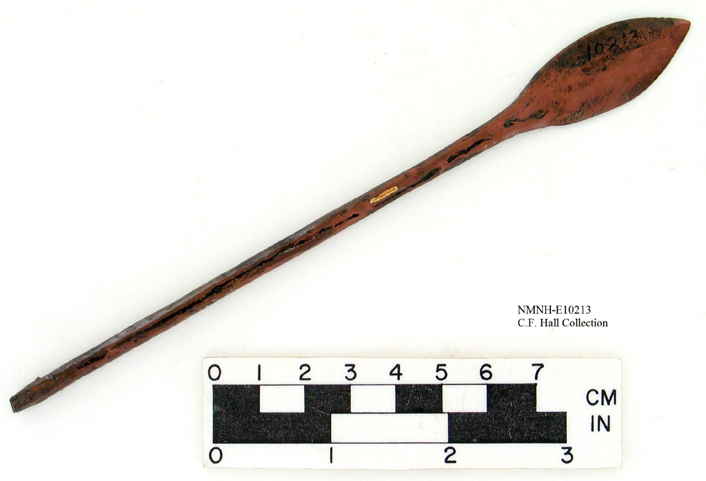
 The most significant aspect of the recently discovered remains of HMS Investigator is not where the ship was located, nor is it the graves found onshore nearby. Rather, it's the copper sheathing of her hull, so brilliantly visible in the most recently released video, a frame of which I've placed here for reference. Thanks to the low oxygen content of the frigid waters of Mercy Bay, the copper is not completely tarnished; indeed, underwater currents seem to have almost polished parts of it. The individual nails, as well as the Roman numerals used to mark off the draught of the ship during loading, are plainly visible. And, while some parts of the sheathing have been shredded or torn off entirely, in other areas it is nearly intact. This is significant for two reasons: 1) It shows that the ship was not heaved up by the ice in such a manner that the copper was readily accessible for any length of time, or the Inuit would surely have recovered more of it; and 2) We can conjecture, therefore, that less copper was recovered from this vessel than was earlier believed, which makes it more likely that copper found to the south and east near the Adelaide Peninsula came from some other source.
Could that mean the "Erebus" and "Terror"? Possibly, although evidence has recently surfaced which seems to indicate that neither vessel was given copper sheathing (see my earlier blog post here). Nevertheless, many of the ship's boats would have had it, and copper in other forms could have been recovered from the wrecks. Since the theory that the Investigator herself drifted to the area where Franklin's ships were abandoned is now disproved, the copper found there takes on potentially new significance. Of course, the copper could have been acquired by trade, but some bits of it, recovered by Hall, still bore the Royal Navy's "broad arrow" mark. It seems unlikely that this copper would have been traded such a distance without being cut up or reworked. I'm in the process of trying to get some images of Hall's copper; the Smithsonian has recently begun photographing artifacts from his collection, such as this lovely copper arrowhead. If any of it bears additional markings, it may well be possible to trace it further, and now that we can discount the Investigator as its source, it may be much more significant.
Subscribe to:
Posts (Atom)